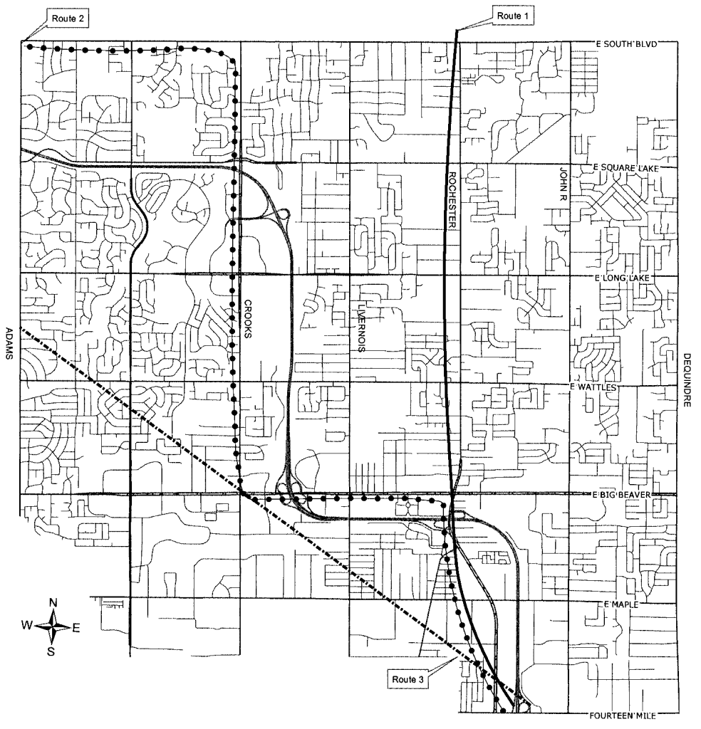
Click map to enlarge
I-75- 5 Routes Proposed
Thursday, Jan. 15, 2015
On January 14, 1959 the Troy City Commission approved the unique route of I-75 through Troy. Because this decision was critical to the development of the City, we will devote this week’s stories to the Interstate Highway system and the platting of I-75 in Michigan and through Troy.
In 1957 The State Highway Department began planning the route of I-75 between the intersection of Telegraph and Square Lake Road in Oakland County and downtown Detroit at where I-75 intersects Holbrook. Between those two points a “planning corridor was established that:
- Was integrated with existing distribution routes in the Metropolitan Area;
- Bypassed other established cities without interfering with their future growth;
- Provided access to existing county roads that were, or might become, principal routes in the area;
- Provided access to planned areas for development; and
- Used the best engineering and construction techniques.
The Detroit Area Traffic Study, the Detroit Metropolitan Area Regional Planning Commission, the City of Troy Planning Commission, plus the studies and recommendations of Troy’s consulting planners, Vilican Lehman Associates were used to propose five different routes:
- Route #1 paralleled Rochester Road and extended north through Troy.
- Route #2 followed Big Beaver Road west to Crooks Road bending towards Pontiac at South Blvd. Vilican Lehman determined this route based on recommendations from their master plan studies and consultation with officials from Chrysler Corporation who considered locating a research facility in Section 9.
- Route #3 entered Troy near the intersection of Stephenson Highway and Fourteen Mile Road and followed a diagonal alignment through the city to the intersection of M-24 and Square Lake Road.
- Route #4 was a further refinement of Route #2. It entered Troy near Stephenson Highway and paralleled Big Beaver Road, turning north at Crooks Road, and west at Square Lake Road to the intersection at M-24. This route was modified by moving the north-south portion from the west side of Crooks Road one half mile east between Crooks and Livernois. This alignment was labeled the “Southern Route”.
- Route #5 combined elements of Routes 2, 3, and 4. It paralleled Stephenson Highway between Rochester Road and John R Road, bending to the west as it crossed Wattles Road and angled northwest at Livernois, following a diagonal path to a point west of Crooks. There it paralleled Square Lake Road to the intersection at M-24.
To commemorate the City of Troy’s 60th Anniversary in 2015, we will publish a different story each day that highlights a person, discovery, or event that occurred locally, regionally, nationally, or even globally between 1955 and 2015 and that helped shape our lives and our community. We will try to post stories on important anniversary dates, but we also realize that dates are less critical than content and context. We will include the facts related to controversial stories, allowing our readers to form their own opinions. We invite you to read and comment on the stories. Your suggestions for topics are also welcome and can be posted on our Facebook page, www.troyhistoricvillage/facebook. You can also email stories or ideas to the 365 Story Editor at ed@thvmail.org.


